Autonomous robotic systems survey ballast tanks and cargo holds for corrosion, coating breakdown, and thickness loss. Vesselinspect fuses visual imaging with ultrasonic measurements, predicts structural degradation, and directs surveyors to the zones that matter most — delivering the unified qualitative and quantitative assessment required by AUTOASSESS Challenge 5.
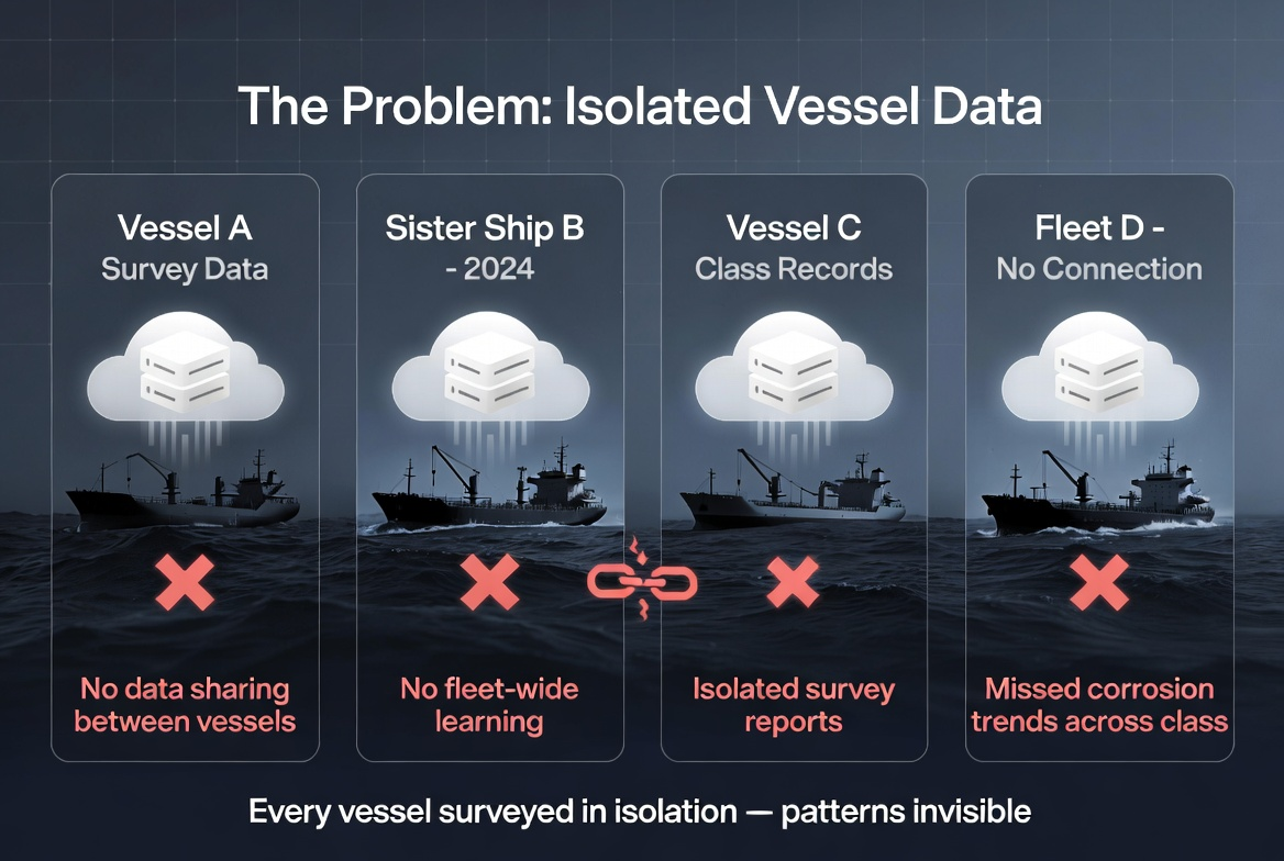
Certified surveyors still enter confined, hazardous ballast tanks and cargo holds to perform visual close-up inspections and ultrasonic thickness measurements. Each survey starts from scratch: no persistent structural record, no correlation between visual corrosion patterns and quantitative thickness loss, no learning across sister vessels.
Patterns that span hundreds of vessels — zone-specific corrosion rates by cargo type and operating profile, repeat problem details at manholes and hopper knuckles, coating performance differences — stay hidden because data never leaves individual survey reports and is never registered to a common class structural model.
Manual surveys burn human risk hours, produce fragmented visual + thickness records, and obscure class-level integrity trends. AUTOASSESS Challenge 5 exists to fix exactly this.

Each layer adds value the previous one cannot deliver by itself — and together they deliver the unified qualitative + quantitative assessment that Challenge 5 demands.
Autonomous aerial robots (hazardous-atmosphere rated) capture high-resolution RGB/multispectral imagery and optional thermal data inside ballast tanks and cargo holds. Routes derived from class structural models guarantee repeatable coverage of critical zones within limited robot endurance.
Built-in quality gates flag blur, low contrast, or coverage gaps and trigger recapture. Targeted UTM probe deployment on AI-ranked hotspots converts visual flags into precise remaining-thickness values against class minima.

Each robotic mission extends a persistent structural integrity record. Software aligns findings to class-approved zones, fuses visual corrosion mapping with UTM readings, tracks progression over 5+ years of surveys, and predicts how thickness loss and coating breakdown will evolve before the next special survey.
A 3D digital twin per tank and vessel fuses imagery, class structural references, historical UTM logs, and expert surveyor annotations into a living model. Vessel-class baselines then estimate when any zone will approach IACS UR-Z10 limits.
Veteran surveyors and naval architects know more than they document. Vesselinspect systematically codifies the tacit expertise that experienced professionals apply but rarely articulate — subtle visual cues for early subsurface corrosion, pattern recognition for moisture-trap geometries, judgment calls on when a finding warrants immediate engineering referral. With an aging surveyor workforce, this knowledge is captured before retirement and embedded in the platform as a durable class resource.
The system outputs priority-ranked worklists driven by structural importance, thickness deviation from class minima, and predicted progression. A fast-growing corrosion zone near a fatigue-critical bracket in a ballast tank tops the list; a stable coating anomaly on a non-structural longitudinal can wait.
Class rule references (IACS UR-Z10), vessel-class degradation models, and expert-validated rationale make that triage auditable and surveyor-ready. Each flagged zone arrives with a recommended action, forecasted intervention window, and direct mapping to survey task cards.

Most robotic inspection tools deliver visual defect maps or isolated thickness readings. Vesselinspect links every finding to its exact class structural zone, historical progression, and predicted trajectory — so surveyors know what matters, what can wait, and when intervention will be needed.
| Typical Robotic Inspection | Vesselinspect | |
|---|---|---|
| What it finds | Visible surface defects in images; separate thickness readings at selected points | Visible defects + quantitative thickness tied to exact structural zones and class limits |
| What it sees beneath coatings | Limited or none in baseline visual systems | Thermal contrast for hidden moisture/delamination; spectral signatures for coating condition |
| What the location means | A coordinate on an image or tank wall | An exact structural zone with known load path, fatigue history, and IACS minimum thickness |
| How priority is set | Visual severity or arbitrary spot sampling | Visual severity + thickness deviation + zone structural importance + predicted progression |
| What history shows | Separate snapshots per survey | Longitudinal records (5+ years) showing stability, spread, or acceleration per zone |
| What happens next | Surveyor decides re-inspection or repair scope | The system forecasts when a zone is likely to reach class allowable limits and recommends intervention timing |
| How results are explained | Confidence scores or raw readings | Measured findings with full structural context, class rule references, and expert-validated rationale |
| What operators & class learn over time | Issues on one vessel at a time | Vessel-class patterns, including repeat problem zones, corrosion rates by operating profile, and effective coating strategies |
Structural integrity intelligence that pinpoints what’s wrong, where it matters structurally, and when you’ll need to act — exactly the unified qualitative and quantitative assessment AUTOASSESS Challenge 5 requires.
Get in Touch